|
|
|||||||||||||||||||||||||||
|
|
About Wokha District
Wokha District is the home of the Lothas. WO in Lotha means NUMBER of PEOPLE and KHA means the COUNTING. So the place in which Lotha ancestors had gathered together and counted their numbers was named WOKHA. In December 1973, Wokha was raised to the status of a separate District. Earlier to this it was one of the sub-division under Mokokchung District. The total geographical area of the district is 1628 sq km with a population of 1,61,098 as per 2001 census. The district is located at an altitude of 1313 MSL with maximum and minimum temperature of 30’C and 10’C respectively. The district receives ample amount of rainfall ranging from 1500-2000 mm annually.
Agriculture constitutes the main occupation for nearly 80% of the population of Wokha District. The primitive method of cultivation, i.e., Jhum system of cultivation is still in practice covering major parts of the district covering an area of 13382 under Jhum cultivation. The farmers of the district also practice the terrace system of cultivation which is however, negligible as most of the farmers of the district are economically very poor and cannot afford to adopt such system of cultivation. The lower plain areas of the district such as Baghty and Ralan are very potential areas where agriculture and all other allied activities can be taken up on a large scale.
The main crops of the district are rice, maize, beans, peas, yam, brinjal, chilly, pumkin, ginger, tomato, bitter-gourd etc. Horticulture products consist of orange, banana, pineapple, papaya ,passion fruit, guava, plum, pear etc.
|
||||||||||||||||||||||||||
|
Administration setup:
Wokha district is headed by Deputy Commissioner with its headquarter at Wokha town. For smooth and effective functioning, the district is divided into various divisions. Bhandari sub-division is headed by A.D.C, Sanis by SDO(C), Merapani by Border Magistrate and the rest by E.A.C. EAC headquarter Englan is a newly established headquarter inaugurated on 10th of November, 2008. Wokha district is divided into 5(five) numbers of Rural Development Blocks viz. Wokha, Chukitong, Wozhuro/Ralan, Bhandari and Sanis block for proper implementation and monitoring of the developmental activities at various levels.
Natural Resources
Changpang is situated in the Lower Lotha Range in the Bhandari Sub-Division. It is around 120 Kms far from the Wokha District Hqrs. ONGC started survey works as early as 1963 in the Changpang area of Nagaland under Wokha District. The survey report indicated that there is sufficient Hydro Carbon (Crude Oil) deposits all along the Nagaland Foothill adjoining Assam. This belt is geographically known as “SCHUPPEN BELT”. ONGC discovered oil in the Changpang area and the trial production started in March, 1981.
The Nagaland State Government stopped all ONGC activities on the 2nd of May, 1994, on matters of Government policy. However, presently there are on-goings talks among the Lothas, Government of Nagaland and the ONGC, for the resumption of operation for exploration and production of petroleum products in the Changpang oil fields.
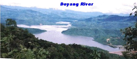
Rivers of the District
Important rivers which flow through the district are Doyang, Chubi, Nzhu and Nruk. Among these, the most popular and the biggest is the Doyang river which flows through the district. The Doyang Hydro Electric Project of the North Eastern Electric Power Corporation Ltd. is being constructed on this river which is situated in Wokha Sadar, 26 Kms from the Wokha district Hqrs. The Doyang Hydro Electric Project (DHEP) covering an area of 3487 ha, was commissioned in the year 2000. It will generate 75 MW of electricity. The commercial operation of the DHEP started w.e.f. 11/07/2000. Apart from the power, fishery is also being promoted in the said river.
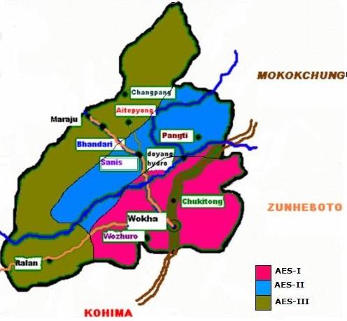
AES I of Wokha district covers
two blocks, i.e., Wokha and Chukitong block. The altitude of this AES
ranges from 750-1350m asl and the soil are mostly acidic. The average
annual rainfall is about 2000-2500 mm. Major enterprises of this situation
are agriculture, horticulture and animal husbandry. Major crops grown are
paddy, maize, sugarcane, chilly, brinjal, beans, orange, passion fruit and
ginger etc. AES II covers only one block
named Sanis block. The altitude of this AES ranges form 165-720m asl. Soil
is acidic with a pH range of 4.5-5.5. The major crops grown include paddy,
maize, chilly, ginger, yam and varieties of vegetables such as cabbage,
knoll-khol, mustard, etc. and horticultural crops such as banana, citrus,
pineapple, litchi, jackfruit etc. Animal husbandry and fish farming are
also practiced by the farmers. AES III of Wokha district covers Bhandari and Wozhuro-Ralan block. The altitude of this AES ranges from 110-304msl. The average annual rainfall is about 2000-2500 mm. Major crops grown are paddy, maize, chilly, brinjal, cabbage, cauliflower, tea, mange, banana, litchi coconut etc. Fish farming and animal husbandry are also taken up.
AGRO-ECOLOGICAL SITUATION MAP OF WOKHA DISTRICT |
|||||||||||||||||||||||||||
|
Website developed and maintained by: KVK Wokha, P.B No.137, P.O Wokha, Nagaland - 797 111 Email_id: kvk_wokha[at]yahoo[dot]co[dot]in/ kvkwokha[at]gmail[dot]com |
|||||||||||||||||||||||||||